|
Click on the map to see site
descriptions and photos
[Indian Arm Main Page]
Admiralty Point | Bedwell Bay |
Belcarra |
Best Point
| Bishop
Bolder Island |
Cates Park |
Croker Island | Granite Falls
|
Grey Rocks | Jug Island
Indian River Estuary | Hamber
Island | Lone Rock Point | Power Station
Silver Falls | Racoon Island | Thwaytes
Landing | Twin Island | Wigwam Inn
|
|
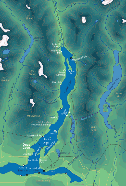
Indian Arm is a scenic fjord
surrounded by spectacular mountains. It is an excellent recreation and tourism
destination. Deep Cove is located only 20 minutes from downtown Vancouver. There
are many destinations along Indian Arm that range from only a half hour to a
full day paddle. On the left is a Map of Indian Arm, click on a destination to
learn more.
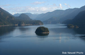
South Arm
Departing from Deep Cove there are several directions you can take to have a
great day trip. The South Arm is dotted with 8 tiny islands that make for great
points of interest during a ?day or day paddle. You can get out and stretch
your legs at Belcarra Beach, Jug Island Beach, Strathcona Bay and Twin Islands.
Paddlers often encounter harbour seals, eagles, flocks of seabirds and other
happy kayakers.
North Arm
Once you pass Best Point, the shoreline homes begin to space out, the shoreline
gets steeper and you begin to feel that you are truly leaving civilization
behind. Rocky cliffs are covered in mustard yellow lichen and the snow covered
peaks of the distant mountains beckon. To travel past Best Point requires
commitment to a long day or overnight trip, but the rewards are worth it.
|