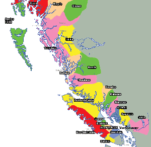
British Columbia


Also see: [Maps of Vancouver]

Maps of British Columbia

Map of Coastal Nations of BC

Click to see full sized-map

Jonathan Ho 2003


Map of West Coast First Nations
  Date:   2003
Map format:   jpeg
Dimension:   800 x 778 pixels (96 kb)
Copyright holder:   Jonathan Ho
Conditions of using this map:   Unlimited educational use, free download.  Free web posting with web link to www.johomaps.com
Computer Specifics:   Prepared using Adobe Illustrator


Map of Georgia Basin

Click to see full sized-map

Jeff Burton, Kyle Gee, Julian Gonzalez, Jonathan Ho,
Alice Miro, Ervin Selak 2004


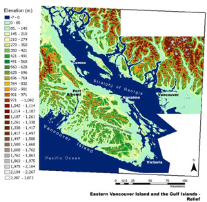
Map of the Straight of Georgia Basin (Relief)
  Date:   2004
Map format:   jpeg
Dimension:   598 x 585 pixels (160 kb)
Copyright holder:   Jeff Burton, Kyle Gee, Julian Gonzalez, Jonathan Ho, Alice Miro, Ervin Selak
Conditions of using this map:   Unlimited educational use, free download.  Free web posting with web link to www.johomaps.com
Computer Specifics:   Prepared using ArcView 8.2


Map of Southern Vancouver Island

Click to see full sized-map

Jeff Burton, Kyle Gee, Julian Gonzalez, Jonathan Ho,
Alice Miro, Ervin Selak 2004


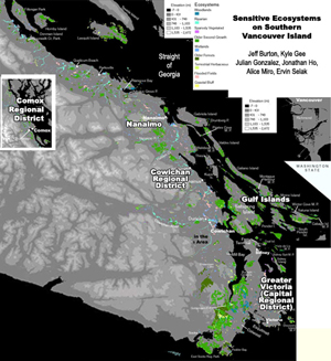
Sensitive Ecosystems on Southern Vancouver Island (Map Series)
  Date:   2004
Map format:   jpeg
Dimension:   598 x 585 pixels (160 kb)
Copyright holder:   Jeff Burton, Kyle Gee, Julian Gonzalez, Jonathan Ho, Alice Miro, Ervin Selak
Conditions of using this map:   All rights reserved
Computer Specifics:   Prepared using ArcView 8.2


Interactive Maps (with Rating by Johomaps *) - External Links


Google Map General Rating:
  • High Definition satellite photo
  • User-friendliness: 4/5
  • Printer-friendliness: 4/5
  • Special Features: Hybrid Maps, i.e., highway info projected on satellite images.  Images are scaled and projections are very accurate
  • Good zoom in and zoom out function
  • Detailed info only appears at appropriate levels to avoid cluttering the map.
Required Program N/A
Orthophoto
Road Names and Highway Numbers
Additional Info Best Map search engine, but only works well in North America and selected cities in Europe.


British Columbia

Mapplace - Interactive Map of BC General Rating:
  • Cultural and Natural features are both mapped and integrated nicely onto the program with real consideration of the limitations of computer screens.  Themes are really well organized and easy to understand.  Many themes that are uncommon to be plotted on interactive media are also found there.  You can even choose how much details you need on your map for rivers and contour intervals.  Good separation of highly technical themes such as geophysical data into separate maps.  Annotation of features.  This site should be a 6 out of 5 if this rating is allowed.
  • User-friendliness: 4/5
  • Printer-friendliness: 4/5 (Useful copy button for copy and paste)
  • Special Features (Natural): Geological info such as faults, fault types, synclines / anticlines, rock unit contact, earthquakes, volcanoes and mineral occurrences, geographic data such as Digital Elevation Model hillshade, bathymetry, detailed watershed info, detailed river info, contour map, glaciers, landsat photo, and even locations of waterfalls.
  • Special Features (Cultural):  Municipalities, electoral districts, regional districts, first nations reserves and treaties, railways, tree farms, landuse and planning, climate stations and even locations of wells!
Required Program Autodesk
Orthophoto  It's very fine.  Turn it on only when zoomed in very closely, not for urban areas
Road Names and Highway Numbers
Additional Info Many natural and cultural themes.  See description on the left


* Ratings are based solely on opinions of our map reviewers.  Financial support and benefits to the web site have no influence on the ratings.