Click to see the full-sized map
|
|
Vancouver Atlas |
||
| Date: | May 2006 | |||
| Map format: | jpeg | |||
| Copyright holder: | Johomaps | |||
| Conditions of using this map: |
All rights reserved.
Contact |
|||
| Computer Specifics: | Prepared using Macromedia Freehand | |||
|
|
||||
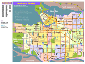
Click to see the full-sized map
|
|
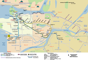
Metro Map of Vancouver |
||
| Date: | Oct 2009 (7th Ed) | |||
| Map format: | jpeg | |||
| Dimension: | 1020 x 702 pixels (522 kb) | |||
| Copyright holder: | Johomaps | |||
| Conditions of using this map: |
All rights reserved.
Contact |
|||
| Note | Click on stations to view map of the vicinity area. | |||
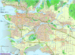
Click to see the full-sized map
|
|
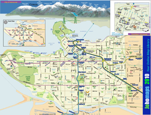
Vancouver City Map |
||
| Date: | Oct, 09 (2nd Ed) | |||
| Map format: | jpeg | |||
| Dimension: | 1662 x 1266 pixels (1.72 MB) | |||
| Copyright holder: | Johomaps | |||
| Conditions of using this map: |
All rights reserved.
Contact |
|||
| Computer specifics: | Prepared using Macromedia Freehand and Adobe Illustrator | |||
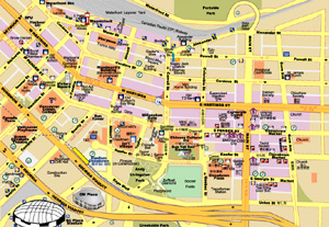
Click to see the full-sized map
|
|
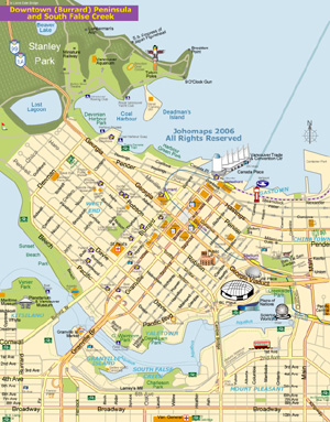
Downtown Map |
||
| Date: | May 2006 | |||
| Map format: | jpeg | |||
| Dimension: | 628 x 801 pixels (596 kb) | |||
| Copyright holder: | Johomaps | |||
| Conditions of using this map: |
All rights reserved.
Contact |
|||
| Computer specifics: | Prepared using Macromedia Freehand and Adobe Illustrator | |||
|
|
||||
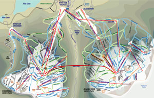
Click to see the full-sized map
|
|
Map of Whistler Blackcomb |
||
| Date: | Jan 2011 | |||
| Map format: | jpeg | |||
| Dimension: | 1183 x 752 pixels (937 kb) | |||
| Copyright holder: | Johomaps | |||
| Conditions of using this map: |
All rights reserved.
Contact |
|||
| Computer specifics: | Prepared using Adobe Illustrator | |||
Click to see the full-sized map
|
|
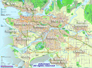
Map of Vancouver Neighbourhoods |
||
| Date: | May 2006 | |||
| Map format: | jpeg | |||
| Dimension: | 1014 x 765 pixels (686 kb) | |||
| Copyright holder: | Johomaps | |||
| Conditions of using this map: |
All rights reserved.
Contact |
|||
| Computer specifics: | Prepared using Macromedia Freehand | |||
Click to see the full-sized map
|
|
Gastown / Chinatown Map |
||
| Date: | May 2006 | |||
| Map format: | jpeg | |||
| Dimension: | 628 x 801 pixels (596 kb) | |||
| Copyright holder: | Johomaps | |||
| Conditions of using this map: |
All rights reserved.
Contact |
|||
| Computer specifics: | Prepared using Macromedia Freehand and Adobe Illustrator | |||
Click to see the full-sized map
|
|
Greater Vancouver Road Map | ||
| Date: | March 2005 | |||
| Map format: | jpeg | |||
| Dimension: | 1851 x 1368 pixels (2.12 mb) | |||
| Copyright holder: | Johomaps | |||
| Conditions of using this map: | Unlimited educational use, free download. Free web posting with web link to www.johomaps.com | |||
| Computer Specifics: | Prepared using Macromedia Freehand | |||
|
|
||||
|
|
Find Johomaps' rail maps on the HippoMetro Web App |