|
|
||||
|
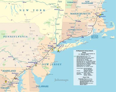
The Northeast megalopolis is the most heavily urbanized region of the United States spanning from the northern suburbs of Boston, Massachusetts, to the southern suburbs of Washington, D.C. in Northern Virginia. On a map, the region appears almost as a straight line. As of the year 2000, the region supported 49.6 million people, about 17% of the U.S. population on less than 2% of the nation’s land area, with a population density of 931.3 people per square mile (359.6 people/km2), compared to the U.S. average of 80.5 per square mile 2[2] (31 people/km2). America 2050 projections expect the area to grow to 58.1 million people by 2025. French geographer Jean Gottmann popularized the term in his landmark 1961 study of the region, Megalopolis: The Urbanized Northeastern Seaboard of the United States. Gottmann concluded that the region's cities — especially Washington, D.C., Baltimore, Philadelphia, New York, and Boston — are, while discrete and independent, uniquely tied to each other through the intermeshing of their suburban zones, taking on some characteristics of a single, massive city: a megalopolis.
|
||||