|
|
|
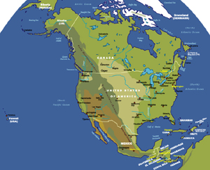
North America - Administrative and Physical | ||
| Date: | April, 2006 (2nd Ed) | |||
| Map format: | jpeg | |||
| Dimension: | 1064 x 880 pixels (206 kb) | |||
| Copyright holder: | Johomaps! | |||
| Conditions of using this map: | Unlimited educational use, free download. Free web posting with web link to www.johomaps.com | |||
| Computer Specifics: | Prepared using Adobe Illustrator | |||
|
|
||||
|
|
|
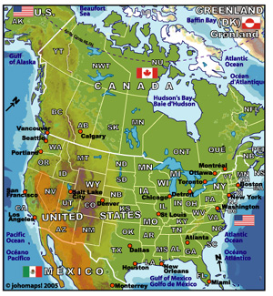
US and Canada - Administrative and Physical | ||
| Date: | May, 2005 | |||
| Map format: | jpeg | |||
| Dimension: | 460 x 498 pixels (304 kb) | |||
| Copyright holder: | Johomaps! | |||
| Conditions of using this map: | Unlimited educational use, free download. Free web posting with web link to www.johomaps.com | |||
| Computer Specifics: | Prepared using Adobe Illustrator | |||
|
|
||||
|
|
|
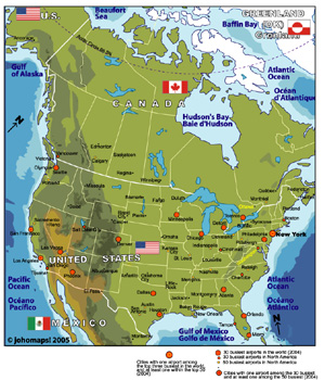
Map of US and Canada - Cities | ||
| Date: | May, 2005 | |||
| Map format: | jpeg | |||
| Dimension: | 758 x 884 pixels (542 kb) | |||
| Copyright holder: | Johomaps! | |||
| Conditions of using this map: | Unlimited educational use, free download. Free web posting with web link to www.johomaps.com | |||
| Computer Specifics: | Prepared using Adobe Illustrator | |||
|
|
|
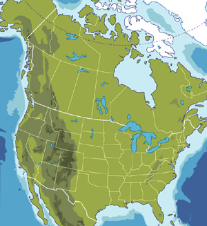
Map of US and Canada - Blank | ||
| Date: | May, 2005 | |||
| Map format: | jpeg | |||
| Dimension: | 722 x 787 pixels (202 kb) | |||
| Copyright holder: | Johomaps! | |||
| Conditions of using this map: | Unlimited educational use, free download. Free web posting with web link to www.johomaps.com | |||
| Computer Specifics: | Prepared using Adobe Illustrator | |||