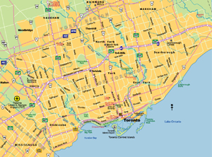
Toronto, Ontario

Local News | Weather | Airport
(All External Links)


Maps of Toronto

City Map of Toronto / Plan de Toronto

Click to see full sized-map

JohoMaps! 2005


Map of Toronto 
  Date:   May, 2005
Map format:   jpeg
Dimension:   959 x 711 pixels (430 kb)
Copyright holder:   Johomaps!
Conditions of using this map:   Unlimited educational use, free download.  Free web posting with web link to www.johomaps.com
Computer Specifics:   Prepared using Adobe Illustrator


Click to see full sized-map

JohoMaps! 2006


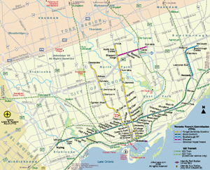
Metro Map of Toronto 

  Date:   May, 2006
Map format:   jpeg
Dimension:   997 x 772 pixels (689 kb)
Copyright holder:   Johomaps!
Conditions of using this map:   All rights reserved, contact for permission 
Computer Specifics:   Prepared using Adobe Illustrator


Rail Map of Southern Ontario

Click to see full sized-map

JohoMaps!


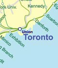
Rail Map of Golden Horseshoe 


[Map links]

Real Time Toronto Travel Info

Weather Now
Click for Toronto, Ontario Forecast 


Exchange


Current Time

Pearson
Flight Info


Mobile Map

City Info

Other names of Toronto:
Old names: York (till 1834)
Nicknames: Hogtown, Cabbagetown, T.O.

Adjective: Torontonian, Torontois (French)

Toronto (From Wikipedia)
Copyright owned by wikipedia.org
See here for copyright and licensing conditions

Toronto is Canada's most populous city, fifth-largest in North America by population (after Mexico City, New York City, Los Angeles, and Chicago), and the provincial capital of Ontario. It has a population of 2,481,494 (2001 Census), and the population of the Toronto Census Metropolitan Area (CMA) is estimated at 5,304,100 in 2005 (Statistics Canada). A Greater Toronto Area (GTA), slightly larger than the Toronto CMA, is defined by provincial authorities for urban planning purposes. The city is part of the Golden Horseshoe, a densely populated region in Ontario of over eight million people. Approximately one-quarter of the Canadian population lives within the Golden Horseshoe, and about one-sixth of all Canadian jobs lie within the city limits.

Toronto is a global city, exerting significant regional, national, and international influence, and is one of the world's most multicultural and ethnically diverse cities: 41% of the population was born outside of Canada. Toronto is Canada's financial centre and economic engine, as well as one of the country's most important cultural, art, and health sciences centres.

[Read full article]


Interactive Maps (with Rating by Johomaps *) - External Links

Toronto Interactive Map (TOMap) General Rating:
  • Maps contain locations of key city services such as emergency and health services
  • Poor display of subway station, lines are not shown.  Road-map based
  • User-friendliness: 3.5/5
  • Printer-friendliness: 3/5
  • Special Features: 
  • Nice query function, click on the "i" button on the toolbar and find out detailed information on the locations marked by the dots and triangles
  • The lack of a legend for the dots and triangles makes the map very hard to read and search.
Required Program N/A
Orthophoto
Road Names and Highway Numbers (no hwy no.)
Additional Info N/A


Google Map General Rating:
  • High Definition satellite photo
  • User-friendliness: 4/5
  • Printer-friendliness: 4/5
  • Special Features: Hybrid Maps, i.e., highway info projected on satellite images.  Images are scaled and projections are very accurate
  • Good zoom in and zoom out function
  • Detailed info only appears at appropriate levels to avoid cluttering the map.
Required Program N/A
Orthophoto
Road Names and Highway Numbers


Reference Maps and Info  - External Links


Map and info of Toronto's Subway and Light Rail System
Maps and the most updated info on the subway system of Toronto.


* Ratings are based solely on opinions of our map reviewers.  Financial support and benefits to the web site have no influence on the ratings.