|
|
||
|
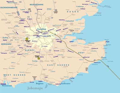
South East England is one of nine official regions of England at the first level of NUTS for statistical purposes. It consists of Berkshire, Buckinghamshire, East Sussex, Hampshire, the Isle of Wight, Kent, Oxfordshire, Surrey and West Sussex. As with the other regions of England, apart from Greater London, the South East has no elected government. The Labour Party's proposals during the general election of 1997 to create elected regional governments were abandoned. It is the third largest region of England, with an area of 19,096 km², and is also the most populous with a total population of over eight and a half million (2011). The headquarters for the region's governmental bodies are in Guildford, and the region contains eight cities: Brighton and Hove, Canterbury, Chichester, Oxford, Portsmouth, Southampton and Winchester, though other major settlements include Reading and Milton Keynes. Its proximity to London and connections to several national motorways have led to South East England becoming an economic hub, with the largest economy in the country outside the capital. It is the location of Gatwick Airport, the UK's second-busiest airport, and its coastline along the English Channel provides numerous ferry crossings to mainland Europe. The region is known for its countryside, which includes the North Downs and the Chiltern Hills as well as two national parks: the New Forest and the South Downs. The River Thames flows through the region and its basin is known as the Thames Valley. It is also the location for a number of internationally known places of interest, such as HMS Victory in Portsmouth, Cliveden in Buckinghamshire, Thorpe Park and RHS Wisley in Surrey, Blenheim Palace in Oxfordshire, Windsor Castle in Berkshire, Leeds Castle, the White Cliffs of Dover and Canterbury Cathedral in Kent, Brighton Pier in East Sussex, and Wakehurst Place in West Sussex. The region has many universities, the most famous being the University of Oxford. |
||