|
|
||||
|
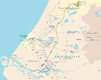
The Randstad is a conurbation in the Netherlands. It consists of the four largest Dutch cities (Amsterdam, Rotterdam, The Hague and Utrecht), and the surrounding areas. With a population of 7,100,000 it is one of the largest conurbations in Europe,[b] comparable in size to Milan or the San Francisco Bay Area and covers an area of approximately 8287 km². The Randstad's main cities are Almere, Amersfoort, Amsterdam, Delft, Dordrecht, Gouda, Haarlem, Leiden, Rotterdam, The Hague (Den Haag in Dutch), Utrecht, and Zoetermeer. Other centres include Alphen aan den Rijn, Amstelveen, Barendrecht, Capelle aan den IJssel, Hilversum, Hoofddorp, Hoek van Holland, Houten, Katwijk, Leidschendam, Maassluis, Nieuwegein, Oostzaan, Purmerend, Rijswijk, Schiedam, Spijkenisse, Vlaardingen, Voorburg, Zeist and Zaanstad. Randstad is an industrial and metropolitan conurbation occupying an area of peat and clay lowlands in west-central Netherlands. Randstad consists of major Dutch industrial cities extending in a crescent (open to the south-east) from Utrecht in the east to Dordrecht in the south and to Lelystad in the north. Randstad is one of the most important economic and densely populated areas in the northwest of Europe. The regions form a ring of four large urban agglomerations (Amsterdam, Rotterdam, The Hague and Utrecht), as well as a number of medium-sized and smaller towns, such Almere, Delft, Leiden and Haarlem. These closely linked agglomerations are situated around the green heart of Holland; a green area, which provides the region not only healthy fresh air but also, room for agricultural activity and for rest and recreation. This combination of space for business activity, residential areas and recreation makes Randstad Region an attractive region both in which to live and to locate businesses.
|
||||