|
|
|||
| World > North America > Canada > BC > Vancouver > Indian Arm | |||
|
|
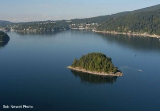
Raccoon Island Raccoon Island is located in the middle of Lower Indian Arm. Small in size, but with a nice little beach at low tide, people often stop here for a rest. It is a good stepping stone to Twin Island. Distance from Deep Cove: 4 km Paddling Time One Way: Fast: 35 min. Avg: 50 min Leisurely: 1 hr Suggested Route: Paddle north from Deep Cove along the west side of Indian Arm until you reach Lone Rock Point a.k.a. Danger Bay Island. From here cross the channel to Raccoon. To return paddle back to Jug Island for a nice circular route. Hazards:
Features: Raccoon Island has a steep rocky shoreline. The best place to access it is on the northwest shore where there is a small rocky beach (beware this beach disappears at high tide). Raccoon Island is a BC Marine Park. There is no drinking water and no outhouse. History: You can locate four depressions in the ground on the middle of the island. A prospector who believed he could find blue diamonds on the island created these depressions. Nature: Raccoon
Island would be more appropriately named Goose Island. In the spring it becomes
infested with aggressive nesting Canada
Geese. If you decide to venture into the
middle of the island during this time the bushes will come alive with hissing of
the territorial geese. Close your eyes and it will seem as if you are surrounded
by snakes! |
||
| Photos and information courtesy of
Deep Cove Canoe and Kayak Centre |
|||

