|
|
Busan, | South Korea |
Local
News |
Weather
| Gimhae
Airport |
|
Maps of Busan |
|
|
|
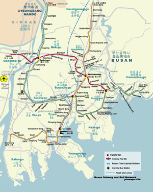
Metro Map of Busan (English and Korean Hangul and Hanja) | ||
| Date: | Aug, 2010 (2nd Ed) | |||
| Map format: | jpeg | |||
| Dimension: | 710 x 890 pixels (269 kb) | |||
| Copyright holder: | Johomaps! | |||
| Conditions of using this map: | All Rights Reserved | |||
| Computer Specifics: | Prepared using Adobe Illustrator and Photoshop | |||
|
|
||||
|
Real Time Busan Travel Info |
|||
|
Weather Now |
|
||

|
City Info |
| Other names of Busan: Pusan (Old transliteration based on closest match to Korean pronunciation) Fushan (Chinese) Busan
(From Wikipedia)
Busan Metropolitan City is the largest harbor city in South Korea. With a population of about 3.65 million, Busan is also South Korea's second largest metropolis, after Seoul. The densely populated city is situated in the narrow Nakdong River valley, with mountains separating some of the various districts. It is located at 35?'10" North, 129?'25" East (35.102778, 129.040278) Busan was the host city of the 2002 Asian Games and APEC 2005. It was also one of the host cities for the 2002 FIFA World Cup. Administratively, it is designated as a Metropolitan City. On November 14, 2005, the city officially announced its bid to host the 2020 Summer Olympics Games. Places of Interest Geumjeong Mountain to the west is a popular weekend hiking spot for Busan residents. To the north, the neighborhoods around Pusan National University (also known as Busan National University) have student theaters, cafes, bars and restaurants, as well as open-air cultural street performances on weekend nights. Tongdo-sa is one of the major three Buddhist temples in Korea. Another temple, Beomeosa, is also very important in Korean Buddhism. Dongnae area is a traditional, rich residential area. Dongnae Oncheon is a natural spa area with many baths, tourist hotels, restaurants, clubs and shopping areas. Many restaurants in the area are famous for their family recipes. Chungyulsa is a Confucian shrine for soldiers who died during the eighteenth century battle against the Japanese at Dongnae castle. Busan is the so-called summer capital of Korea since it attracts tourists from all over the country to its six beaches. High class hotels and a carnival boardwalk line the Haeundae Beach district, which is generally regarded as one of the most beautiful beaches in Korea. Gwangan Beach is famous for its cafes, bars, and restaurants along the beach. The area around Pukyong National University and Kyungsung University has many cafes, bars and restaurants attracting college students and youth. Seomyeon is recognized as the new downtown with many cafes, bars, restaurants, shops and shopping centers. The Gwangbok-dong and Nampo-dong areas form the old downtown with many cafes, bars, shops and restaurants. Some of the restaurants in the area are famous with family recipes passed down the generations. Jagalchi Market (near the very active port) is an area of narrow street stalls and is well known for its fish market. Taejongdae, is a natural park with magnificent cliffs facing the open sea on the island of Yeongdo. History Geochilsan-guk existed in the second and third centuries as a chiefdom of Jinhan. It was absorbed by Silla and renamed Geochilsan-gun. The word Geochilsan means rough mountain, probably referring to Hwangryeong-san, located at the center of the city. In 757, Geochilsan-gun was again renamed Dongnae, which it is still called. From the beginning of the fifteenth century, the Korean government designated Busan as a trading port with the Japanese and allowed their settlement. Other Japanese settlements in Ulsan and Jinhae diminished later, but the Busan settlement, called Waegwan at the time, continued until Japan invaded Korea in 1592. After the war, diplomatic relations with the new shogunate in Japan were established in 1607, and Busan Waegwan was permitted to be reconstructed. The Japanese settlement, though relocated into Choryang later, continued to exist until Korea was exposed to modern diplomacy in 1876. In 1876, Busan became the first international port in Korea. During the Japanese occupation, Busan developed into a hub trading port with Japan. Busan was also the only city in Korea to adopt the steam tramway before electrification was introduced in 1924. Since 1978, Busan has opened three container ports including Jaseungdae, Shinsundae and Gamman. Busan is renowned as one of the world's largest ports and can handle up to 6.44 million TEU shipping containers per year. The Busan Coastal Ferry Terminal serves ferry services to many locations on Geoje Island as well as to Jeju City in Jeju-do. Ferries leaving from the International Ferry Terminal on Busan Harbor Pier 1 connect Busan to the japanese ports of Izuhara and Hitakatsu on Tsushima Island, as well as the cities of Shimonoseki, Fukuoka, and Osaka on Japan's mainland.
Busan lies on a number of rail lines, of which the most important is the Gyeongbu Line which connects it to other major cities such as Seoul, Daejeon, and Daegu. All classes of trains run along the Gyeongbu Line, including the KTX trains which provide service to Seoul in approximately 150 minutes. The Gyeongbu Line terminates at Busan Station. Other lines include the Donghae Nambu Line. The Busan Subway network contains three lines: Line number 1, Line number 2, and Line number 3. It's operated by the Busan Transportation Corporation. Travel Tips
|
![]()
![]()