|
|
|
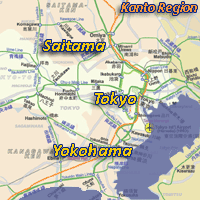
Saitama Map | ||
| Map format: | gif | |||
| Dimension: | 347 x 657 pixels (13.2 kb) | |||
| Copyright holder: | CityRailTransit | |||
| Conditions of using this map: |
All rights reserved. Contact
|
|||
|
||||
|
Saitama, Japan |
Weather
| Narita Airport |
|
Maps of Saitama, Japan |
|
|
|
Saitama Map | ||
| Map format: | gif | |||
| Dimension: | 347 x 657 pixels (13.2 kb) | |||
| Copyright holder: | CityRailTransit | |||
| Conditions of using this map: |
All rights reserved. Contact
|
|||
|
|
||||
|
Real Time Saitama Travel Info |
|||
|
|
|||
|
City Info |
|
Saitama City (From Wikipedia)
Saitama (さいたま市, Saitama-shi) is the capital and the most populous city of Saitama Prefecture in Japan, situated in the south-east of the prefecture. Its area incorporates the former cities of Urawa, Ōmiya, Yono and Iwatsuki. It is a city designated by government ordinance. Being in the Greater Tokyo Area and lying 15 - 30 kilometres north of central Tokyo, many of its residents commute into Tokyo. |
![]()
![]()

