|
|
||||
|
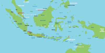
Indonesia, officially the Republic of Indonesia (Indonesian: Republik Indonesia), is a sovereign state in Southeast Asia and Oceania. Indonesia is an archipelago comprising approximately 17,508 islands. It encompasses 33 provinces and 1 Special Administrative Region (for being governed by a pre-colonial monarchy) with over 238 million people, making it the world's fourth most populous country. Indonesia's republic form of government comprises an elected legislature and president. The nation's capital city is Jakarta. The country shares land borders with Papua New Guinea, East Timor, and Malaysia. Other neighboring countries include Singapore, the Philippines, Australia, Palau, and the Indian territory of the Andaman and Nicobar Islands. Indonesia is a founding member of ASEAN and a member of the G-20 major economies. The Indonesian economy is the world's 16th largest by nominal GDP. The Indonesian archipelago has been an important trade region since at least the 7th century, when Srivijaya and then later Majapahit traded with China and India. Local rulers gradually absorbed foreign cultural, religious and political models from the early centuries CE, and Hindu and Buddhist kingdoms flourished. Indonesian history has been influenced by foreign powers drawn to its natural resources. Muslim traders brought the now-dominant Islam, while European powers brought Christianity and fought one another to monopolize trade in the Spice Islands of Maluku during the Age of Discovery. Following three and a half centuries of Dutch colonialism, Indonesia secured its independence after World War II. Indonesia's history has since been turbulent, with challenges posed by natural disasters, corruption, separatism, a democratization process, and periods of rapid economic change.
|
||||